8-Day Iceland Road Trip Itinerary: Ring Road & Westfjords

Last updated:

This post may contain affiliate links. When you book through one of these links, I earn a small commission at no extra cost to you. I appreciate your support to keep creating honest and valuable travel content.


We used the abundance of daylight in early August to our advantage, driving the entire Ring Road and venturing out to the Westfjords in eight packed travel days. This eight-day road trip itinerary covers the best of Iceland from the Ring Road to the Westfjords, including unique places to stay.

Day 1: Arrival & The Golden Circle

If arriving on a late flight like us, you can book an Airbnb around the airport to get a couple hours of rest. Most international flights into Keflavik International Airport arrive early in the morning, perfect for making the most of your travel day. This comes naturally in Icelandic summer: the sun doesn’t set until 11 PM and rises around 4 AM in early August, with a golden hour that never seems to end.

Traffic light showing a yellow light at dawn near buildings and a street.
A majestic waterfall cascading down rocky cliffs surrounded by lush green grass and hills, with people standing nearby admiring the view under a cloudy sky.

Morning: Þingvellir National Park, Kerið crater, Friðheimar Farm

The first day in Iceland is dedicated to the Golden Circle, a popular 300-km loop from Reykjavik that connects several highlights. Start at Þingvellir National Park, Iceland’s former political center with a dramatic setting at the crossing of two tectonic plates. On the way to lunch, a small detour leads to Kerið crater, which turns vibrant blue on sunny days. Friðheimar Farm serves a farm-to-table lunch in their greenhouses, where they grow tomatoes year-round.

A scenic view of a narrow river winding through rocky terrain, surrounded by greenery and low shrubs, with mountains in the background under a cloudy sky.
A scenic view of a rocky canyon with lush vegetation on either side, winding pathways, and distant mountains under a cloudy sky.
A scenic waterfall cascading over rocky cliffs into a river, surrounded by lush green moss and boulders under a partly cloudy sky.
A scenic view of a volcanic crater lake surrounded by colorful rocky walls and lush greenery, with visitors gathered along the shoreline.
Interior of a greenhouse featuring two women at a dining table surrounded by vibrant flowering plants and sunlight filtering through the structure.
A dining table set with various dishes including a bowl of red soup, slices of bread, a dish of butter, a small bowl of green salad, and a cup of sour cream. There are also glasses of water and a menu on the table.

Afternoon: Geysir Hotspring Area, Gulfoss Waterfall

After lunch, continue to the other two attractions on the Golden Circle. The Geysir Hotspring Area is a collection of sizzling hot springs and geysers. Even if you don’t see the famous Great Geysir in action, an eruption from Strokkur Geyser is almost guaranteed. Ten minutes down the road is the impressive Gulfoss Waterfall, the largest waterfall in Europe by volume.

A geyser erupting water into the air, surrounded by a rocky landscape and a crowd of spectators in the background under a blue sky.
A geyser erupts, sending a water column into the blue sky, with a crowd of spectators observing from a distance.
A scenic view of a waterfall cascading into a river, surrounded by lush greenery and a rocky landscape, with visitors walking along a pathway.

Stay: Lindartún Guesthouse

Instead of looping back to Reykjavík, we continued southeast for 110 km to Lindartún Guesthouse. This small guesthouse is tucked away in the countryside. The hostess prepares a delicious breakfast in the mornings and you can use the shared kitchen to prepare dinner. Given the remoteness of many locations and high restaurant prices, we opted for stays with kitchen facilities throughout our trip.

Three women sitting at a table in front of a small house, enjoying snacks and drinks, with a scenic landscape and cloudy sky in the background.
A plate of waffles topped with whipped cream and syrup, accompanied by slices of watermelon, cantaloupe, honeydew, pineapple, and green grapes, with a cup of coffee in the background.

Day 2: Fimmvörðuháls Trail

The Fimmvörðuháls Trail is one of Iceland’s iconic day hikes, traversing incredibly diverse and surreal landscapes on a 24-km trail from Skógar to Þórsmörk. What is even tougher than the hike itself is arranging the logistics to complete it. The trail is done point-to-point, with the return by off-road bus. We started the hike from Skógafoss waterfall at 10:30 AM with destination Þórsmörk Básar Huts, planning to return on the 8:30 PM bus from Southcoast Adventure to the Skógafoss parking lot.

A wide view of a stunning waterfall cascading down rocky cliffs, surrounded by lush green hills under a blue sky.

The trail can be divided into three parts. The first section winds up next to Skógafoss through a lush green canyon, passing another 25 waterfalls. It entails a constant but gentle climb over a course of 8 km, surrounded by stunning scenery. The end of this section is marked by the wooden bridge over the Skógá River.

A serene landscape featuring a flowing river with cascading waterfalls surrounded by lush green hills under a cloudy sky.
Two women standing by a river in a mountainous area, with green grass and rocky terrain around them.
A scenic view of a waterfall cascading through lush green valleys and rocky outcrops, with mountains visible in the background under a cloudy sky.
Scenic view of a green canyon with a river running through it, surrounded by hills and cliffs under a cloudy sky.

The green pasture makes way for a barren and rocky landscape before leading up to the snow-covered Fimmvörðuháls Pass. This is the most strenuous section of the hike, as you plow through snow fields and volcanic soil while exposed to the elements. The last part of this section runs between glaciers Mýrdalsjökull and Eyjafjallajökull, passing lava fields created by the volcanic eruption that shut down Europe’s airspace in 2010.

A scenic landscape featuring a rocky path leading to a small, white triangular-shaped building, with snow-capped mountains and a cloudy sky in the background.
A rugged volcanic landscape with black lava rock and snow patches in the background, featuring a wooden signpost labeled 'Fimmvorduskali' pointing towards 'Basar'.
A view of a glacier with hikers approaching the icy surface, surrounded by rocky mountains and a cloudy sky.
A snow-covered landscape with hikers traversing a glacier, under a cloudy sky.
A group of hikers silhouetted against a cloudy sky, ascending a black volcanic hill surrounded by white snow and ice.

The last section of the hike is a thrilling descent into Þórsmörk through a spectacular canyon. There are a couple of nerve-wracking parts, even if you just have a remote fear of heights. At one point the trail clings to a cliff, with a loose-hanging rope barely providing support. The grand finale is the cat’s spine, a narrow path flanked by the abyss on both sides.

A panoramic view of a lush green valley surrounded by rugged mountains under a cloudy sky, with a winding river flowing through the landscape.
A panoramic view of a rugged mountain landscape with steep cliffs, green slopes, and patches of snow under a cloudy sky.
A narrow dirt path winding along a green hillside with rocky cliffs, under a cloudy sky.
A scenic landscape featuring steep green hills and rugged rock formations under a cloudy sky.

We arrived at the Þórsmörk Básar Huts around 6:30 PM, clocking in at eight hours of hiking time. The 8:30 PM bus made a stop at Seljalandsfoss right before arriving to Skogar. This waterfall is unique because you can walk underneath it, sheltered by a cove. We stopped at the waterfall before the hike, but golden hour only adds to its beauty.

A stunning waterfall cascading down rocky cliffs, surrounded by lush greenery and a serene landscape with a river flowing below.
A scenic view of Seljalandsfoss waterfall in Iceland, cascading over a rocky cliff surrounded by lush green grass and a cloudy sky, with visitors walking along a path in the foreground.
A powerful waterfall cascading down a rocky cliff, surrounded by lush greenery and a serene landscape.

Stay: Skogafoss Campsite

We rented a tent at Skogafoss Campsite through Airbnb. Finding a tent ready to dive into after a long day of hiking was perfect. In the morning, the first thing you see when opening the tent is Skógafoss waterfall without the crowds. For a little more comfort, you could stay at Guesthouse Skógafoss within walking distance from the fall.

A scenic campsite with colorful tents set in a grassy area near a waterfall, under a blue sky with scattered clouds.
A green tent set up on a grassy area with a picturesque waterfall in the background, surrounded by rolling green hills under a blue sky.

Day 3: South Coast

Morning: Reynisfjara, Fjaðrárgljúfur

Today is a driving day, as you follow the Ring Road for 500 km along the southern coast to the Eastfjords. Route 1 is known as the Ring Road because it loops around Iceland, connecting many of the country’s highlights. The road is part of the destination, with beautiful scenery and many stops along the way. The first one is the famous Reynisfjara black sand beach. You can take a short detour to Dyrholaey Peninsula for views of the beach and a puffin encounter. Continue to Fjaðrárgljúfur, a stunning canyon accessed by a short but bumpy gravel road.

A scenic view of a coastline featuring a black sand beach, grassy hills, and rocky cliffs under a cloudy sky.
A scenic beach with black pebbles, featuring tall rock formations and a cloudy sky. A few people can be seen walking along the shoreline.
A close-up view of basalt columns along a rocky cliff, partially covered with grass, leading to a dark cave entrance.
A scenic view of a waterfall cascading down a rocky gorge surrounded by lush green moss and grass.
A scenic view of a canyon with steep, moss-covered cliffs and a winding river at the bottom, under a cloudy sky.

Afternoon: Vatnajökull National Park

Vatnajökull National Park is the largest national park in Iceland, named after the largest glacier in Europe. The Skaftafellsstofa Visitor Center is located right off the Ring Road. A one-hour round trip trail from the visitor center runs to the spectacular Svartifoss waterfall. Enjoy lunch with views of the glacier from the cafe inside the park. The scenic glacier lake Jökulsárlón is also located in the national park, but accessed by continuing on the Ring Road for another 45 minutes.

Two women enjoying a meal at an outdoor table, with a scenic view of mountains and a glacier in the background. One woman is eating a sandwich while the other has a bowl of soup. A walking path and other hikers can be seen in the distance.
A scenic view of a waterfall cascading down rocky cliffs surrounded by lush green hills and a rocky stream in the foreground.
A stunning waterfall cascading down striking basalt columns, surrounded by lush greenery and rocky terrain.
A serene glacial lagoon featuring floating icebergs and calm turquoise waters, with mountains in the background under a partly cloudy sky.

Stay: Stora Sandfell Cottages, Eastfjords

We booked a stay in the Eastfjords, another three-hour drive from Jökulsárlón. The last 50-km stretch to Stora Sandfell Cottages takes you inland, off the Ring Road. We were relieved to find these little fairytale houses after making it through a thick mist in the mountains. The cottages are very small but well-equipped, with a sweet local lady as the hostess.

A scenic view of red wooden cabins set in a grassy area surrounded by trees, with barbecue grills and picnic tables in the foreground.

Day 4: Eastfjords & North Iceland

Morning: Eastfjords, Dettifoss

From the Ring Road, a quick 30-minute detour leads to the Eastfjords. The eastern coast of Iceland is made up of dramatic fjords that house picturesque fishing villages, like Seyðisfjörður. The town has a scenic mountain backdrop with clear skies, but manages to keep its charm even on a misty day. Continue north on the Ring Road to the Diamond Circle, which connects several impressive sights in northern Iceland. The first one is Dettifoss, the most powerful waterfall in Europe.

A scenic landscape featuring a green field with large black hay bales, under a cloudy sky with a rainbow in the background.
A picturesque view of a small town by a tranquil body of water, with colorful houses and a white church set against a steep, green mountain backdrop.
A close-up view of a coffee cup on a saucer in front of a window, with a cloudy mountain landscape and colorful buildings visible outside.
View of Dettifoss waterfall in Iceland, featuring a rainbow in the mist and visitors along the paths overlooking the falls.

Afternoon: Diamond Circle, Akureyri

The attractions on the Diamond Circle become more surreal by the mile. The Krafla Víti Crater and Hverir Geothermal Area transport you to a different planet. You can skip the entrance fee to Mývatn Natural Baths, as there are free and better-smelling hot springs yet to come. The last stop on the Diamond Circle along Route 1 is Goðafoss waterfall, followed by a scenic stretch that leads to Akureyri. We treated ourselves to dinner at gastropub Strikið in the country’s second biggest city.

A scenic view of a volcanic crater lake with turquoise water surrounded by brown rocky terrain and green grass, under a cloudy sky.
A geothermal area featuring steam vents and mineral-rich soil, with a mountainous backdrop and several people exploring the landscape.
Two women stand smiling in front of a waterfall, with rocky terrain and green hills in the background under a cloudy sky.
A scenic winding road along a coastline, with rolling green hills and a mountain range in the background under a clear blue sky.
A scenic view of a town with colorful houses, surrounded by trees and mountains under a soft sunset sky.

Stay: Guesthouse Baegisa

Guesthouse Baegisa is part of a working farm just west of Akureyri. This beautiful farm stay is scenically located between meadows and mountains. The lovely hostess prepares a delicious breakfast buffet in the morning, made with produce from the farm.

A scenic view of a rural farm with two buildings featuring red roofs, a gravel path, and wrapped hay bales in the foreground, set against a backdrop of green hills and mountains under a clear blue sky.
A breakfast table setting with a plate of scrambled eggs, slices of banana, an apple, dark bread, and cream. A cup of coffee is nearby, along with a teapot and various drinks including orange juice and yogurt. A map and utensils are also present on the table.
A countertop displaying various jars of jam, yogurt, and containers of cereal, with a scenic view of greenery and mountains visible through a window.
A serene landscape featuring green fields with grazing sheep, surrounded by mountains with snow-capped peaks and a few buildings in the distance under a clear blue sky.

Day 5: Road to the Westfjords

From Akureyri, it takes close to four hours to reach the base of the Westfjords. The northwestern peninsula is one of the most gorgeous yet untouched parts of Iceland, as less than 10% of tourists make it there. We added a detour around Tröllaskagi Peninsula, but mist prevented us from taking in the spectacular coastline. On clear days, the heated infinity pool of Hofsós comes with extensive fjord views. But even covered in mist, it is the perfect break on a long driving day.

A scenic outdoor swimming pool with several people swimming and relaxing. In the background, a calm body of water meets cloudy skies and distant mountains.
A serene landscape featuring cows grazing on a grassy field dotted with wildflowers, alongside a calm body of water under a partly cloudy sky.

Stay: Country Hotel Heydalur

You’ll want to arrive early at this scenic farm stay in the heart of the Westfjords. Country Hotel Heydalur‘s serene surroundings make for a relaxing afternoon. A 10-minute walk through the countryside leads to a natural hot spring. Iceland is home to an abundance of these pristine hot springs, and the Westfjords house many of them.

A scenic landscape featuring rolling green hills and a clear blue sky. In the foreground, wildflowers bloom in a grassy field. A farm with several buildings is visible at the base of the hills.
Two women enjoying a natural hot spring while holding drinks, surrounded by lush green grass and wildflowers, with a mountain in the background.
A person standing on rocks in a shallow river with a green hillside and a few buildings in the background under a blue sky.
A small white house with a red roof situated in a green valley, surrounded by tall grass and wildflowers. In the background, rolling hills and a blue sky are visible, with round bales of hay scattered across the field.

Day 6: Westfjords

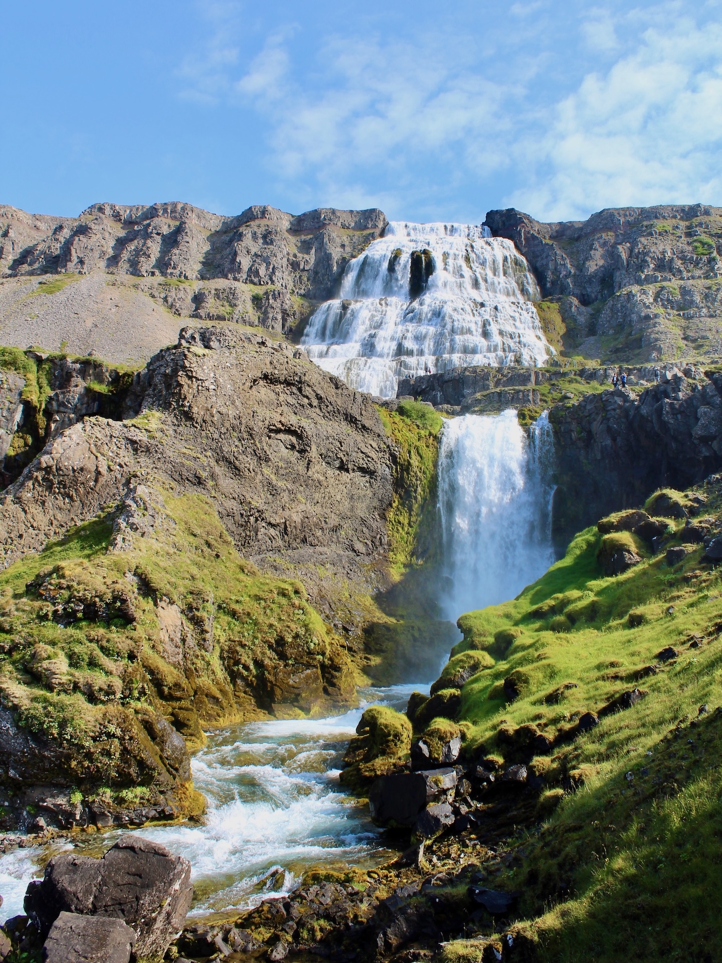
Morning: Road to Dynjandi Waterfall

The only road around the Westfjords clings to the fjords without guardrails, assuring some scary moments but above all spectacular views. We started our favorite day of this trip with coffee and a whale sighting at Litlibær Farm, followed by beautiful scenery and tiny fishing villages on the way to Dynjandi waterfall. Just when you are reaching a waterfall-saturation point, this impressive multi-layered waterfall leaves you in awe.

A serene landscape featuring a winding river flowing through grassy banks, surrounded by mountains under a cloudy sky.
Two women sitting at a picnic table by a calm lake, with an Icelandic flag waving in the foreground and mountains in the background under a cloudy sky.
A scenic view of mountains and a tranquil body of water, with round hay bales scattered across a green field in the foreground.
A stunning waterfall cascading down rocky cliffs, surrounded by lush green grass and small boulders, under a partly cloudy blue sky.
A scenic view of a waterfall cascading over rocky cliffs, surrounded by lush greenery and mountainous terrain.
A scenic waterfall cascading down rocky cliffs surrounded by lush green vegetation and a winding river beneath.
A scenic view of a fjord surrounded by steep, grassy hills under a blue sky with scattered clouds.

Afternoon: Reykjafjardarlaug Pool, Látrabjarg Cliffs

The Reykjafjardarlaug Pool appears as a Fata Morgana next to the road, unmanned but well-kept, with hot thermal waters and stunning views of the fjords. Before heading further into no man’s land, stock up on groceries in Patreksfjörður. On the way to the westernmost point of Europe, you pass the photogenic church of Breiðavík. The road to the Látrabjarg Cliffs is long but perfectly doable in a regular car. Iceland is home to 60% of the Atlantic puffin population, which come to nest at these cliffs in summer.

Two women enjoying a swim in a clear blue pool surrounded by mountains and a bright sky.
A person swimming in a green-tinted pool surrounded by mountains and a serene landscape under a blue sky.
Two people relaxing by the water, sitting on a ledge with clear turquoise water around them and mountains in the background.
A small white church with a red roof situated in a grassy field near the ocean, with mountains in the background and a cloudy sky.
A small white church with a red roof set against a vast green landscape and a sandy beach, with cliffs in the distance under a partly cloudy sky.
A puffin standing on a rocky cliff with a blue ocean in the background.
Two puffins standing on a grassy cliff overlooking the ocean.

Stay: Hænuvík Cottages

The location of Hænuvík Cottages is best described as the end of the world. It takes a brief sidetrack onto a desolate road to reach the cottages when returning from the Látrabjarg Cliffs. The basic cottages lack any type of comfort, but a unique stay in a secluded setting is guaranteed.

A small white house with a red roof by the shoreline, surrounded by green grass, with mountains in the background and a person standing next to the house.
A scenic view of a coastal landscape featuring a flat-topped cliff, green fields, and a few small houses with red roofs, under a cloudy sky.
A small white house with a red roof situated on a green grassy landscape next to a body of water, with mountains in the background under a cloudy sky.

Day 7: Snæfellsnes Peninsula

Morning: Baldur Ferry to Snæfellsnes Peninsula

The Baldur Vehicle Ferry runs between Brjánslækur on the Westfjords and Stykkishólmur on the Snæfellsnes Peninsula. Before boarding the 2:00 PM ferry, you can take a short but curvy detour to Rauðisandur Beach. A series of hairpin curves lead to this remote beach with red sand. The ferry transports you from one peninsula to another in three hours. Driving would take around the same time, but after more than 2,000 km we preferred to take in the scenery from the ferry deck.

A coastal view of a small harbor with multiple fishing boats docked, surrounded by colorful residential buildings and green hills under a cloudy sky.
Two women standing beside a bright orange lighthouse on a grassy hill, with rocky terrain surrounding it under a cloudy sky.
A scenic view of a coastal village with colorful houses, docks, and boats in the water, surrounded by mountains under a cloudy sky.

Afternoon: Snæfellsnes Peninsula

Stykkishólmur is a charming fishing village in the heart of the Snæfellsnes Peninsula, a short drive from the emblematic Kirkjufell. The peninsula’s scenic coastline is best appreciated from a hike. An easy 1-hour trail with stunning views runs between the towns of Arnarstapi and Hellnar. Enjoy a typical coffee break with waffles halfway at Fjöruhúsið Café. Head back to the Ring Road and complete the loop to Reykjavík, with a dip in Landbrotalaug Hot Springs on the way.

A scenic view of Kirkjufell mountain with a waterfall in the foreground, surrounded by green hills and overcast skies, with a few people walking along a path.
Scenic coastal view featuring rocky landscapes, calm waters, and distant mountains under a partly cloudy sky.
A close-up of a waffle topped with whipped cream and syrup, served on a plate with a cup of coffee and additional waffles in the background on a wooden table.
Two women sitting at a wooden table on a deck by the sea, enjoying coffee and each other's company on a sunny day.
Two individuals walking along a gravel path in a picturesque landscape with mountains and cloudy skies in the background.

Stay: KEX Hotel, Reykjavík

We stayed in KEX Hotel in Reykjavík, housed in a former cookie factory. There are various accommodation options, from dorms to private rooms with shared bathroom and regular hotel rooms. The hostel is hip like its host city and offers a healthy breakfast buffet.

Interior of a modern bar or cafe with colorful chairs, a counter, and staff serving drinks, featuring a chalkboard menu and ambient lighting.

Day 8: Reykjavík & Blue Lagoon

Morning: Reykjavík

The final day in Iceland is reserved for exploring the capital and most famous attraction. Reykjavík is very compact and can easily be explored on foot. The Hallgrímskirkja Church is the city’s landmark building and a great place to start. Take the lift to the top of the church for views of the colorful city streets. The Old Harbor houses restaurants in former warehouses. Embark on a culinary seafood tour with lobster soup from Sægreifinn, followed by a delicious fish pan at Messinn. The charming streets of the Old Town are perfect for a stroll after lunch.

A panoramic view of Reykjavik, Iceland, showcasing a colorful array of buildings, streets, and the harbor in the distance under a cloudy sky.
Aerial view of a residential area in Reykjavik, Iceland, showcasing colorful rooftops and greenery under a cloudy sky.
Storefront of a shop displaying plush puffin toys and souvenirs, with a large puffin mascot in the window, featuring a 'Buy 3 Get 1 Free' sign.

Afternoon: Blue Lagoon

No first visit to Iceland would be complete without a dip in the iconic Blue Lagoon. Advance reservations are necessary, as popular time slots sell out. We made a reservation at 8 PM to avoid the biggest crowds. The standard package comes with a drink from the in-water bar, a mud mask and access to the complex of pools, sauna and steam cave. Soaking in the silky waters turned out to be the perfect way to relax prior to our 6 AM flight home.

Two women smiling and standing in a geothermal hot spring, surrounded by mist and other bathers, with mountains in the background.

One response to “8-Day Iceland Road Trip Itinerary: Ring Road & Westfjords”

  1. What a fab trip! I’m heading to Iceland in a few weeks so won’t be doing the full ring road in winter, but will be doing a good portion of it! Some of the northern areas look amazing – that Dynjandi waterfall, wow!

Leave a Reply

Discover more from Klara the Explorer

Subscribe now to keep reading and get access to the full archive.

Continue reading